Fallout (China-North Korea border, United States, 2017)
In this exhibition commission for the Nobel Peace Prize 2017 — won by the International Campaign to Abolish Nuclear Weapons (ICAN) — I created a series of diptychs pairing nuclear-related landscapes from the North Korea-China border and the United States.
My intention was to get the viewer to suspend their sense of place and perhaps moral judgement: who gets to call whom a “rouge state” or decide how many nuclear warheads is too many?
Featured in The New Yorker: https://video.newyorker.com/watch/the-traces-of-nuclear-bombs

Hatches over silos which in the 1970s held missiles meant to shoot down incoming Soviet warheads, North Dakota, November 2017. / A missile field in rural North Dakota near the Canadian border which held Sprint and Spartan anti-ballistic missiles designed to intercept attacking nuclear warheads from Soviet missiles coming over the North Pole. These were deployed at the Stanley R. Mickelsen Safeguard Complex near Langdon, North Dakota, in the mid 1970s – a radar and anti-ballistic missile defence site which was shuttered by 1979.
Right:
The North Korean city of Hyesan, about 120km from North Korea’s nuclear test site, October 2017. / The city of Hyesan in North Korea’s Ryanggang province sits across the Yalu River from the Chinese border town of Changbai. Hyesan is 120 km from the Punggye-ri nuclear test site where North Korea is estimated to have conducted six underground nuclear tests since 2006. Japanese news reports in October (2017) said that a tunnel at the site had collapsed, killing as many as 200 North Koreans. Pyongyang’s latest nuclear test, on September 3 (2017) recorded as a 6.3-magnitude earthquake in North Korea’s northeast. — From “Fallout”, a series on humans’ experience with nuclear weapons, past and present.

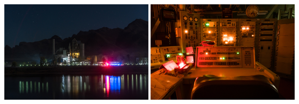
A factory producing into the night, in Manpo, North Korea, October 2017. / A factory, perhaps making cement, continues production into the night in Manpo, Chagang Province, North Korea, photographed from across the Yalu River from close to the northeastern Chinese city of Ji’an, Jilin province.
Right:
The desk of a commander in the control room of a decommissioned Titan II Missile Site in Arizona, November 2017. / This was the desk of a launch commander in a control center which could fire a Titan II Missile tipped with a 9 megaton thermonuclear warhead – the largest warhead ever deployed on an ICBM by the United States. There was a “No Lone Zone” rule here, meaning there were always at least two members of the crew present. If they received orders to launch a missile, they would each have to turn a launch key at exactly the same time. Once their keys were turned, the missile took 58 seconds to launch and 25 to 30 minutes to reach its target which could be 9,700km away. Crew members were never told where the missiles were targeted at. That launch order never came. This site, operational from 1963 to 1982, is now a museum.

Right: Looking from China into North Korea over Mount Paektu, elevation 2,744 m, an active volcano on the border of the two countries. The mountain and the crater lake formed by a volcanic eruption are divided between North Korea and China. The highest mountain on the Korean peninsula and northeast China, it is regarded by North and South Koreans as a sacred place that is their countries’ spiritual home. Imagery of this mountain features in many North Korean propaganda paintings.
October 28, 2017

Fence along the China-North Korea border, near Tumen city, May 2015. / China and North Korea share a 1,420km border, separated by two rivers and a mountain. This gate was in a fence along the China-North Korea border near the Chinese city of Tumen, just across the Tumen River from the North Korean town of Namyang. Tumen City offers clear views into North Korea and attracts Chinese tourists — and sometimes North Korean fugitives who wade across the river into China. There is a large ethnic Korean population native to Tumen city which is a part of Yanbian prefecture. In early 2015, there were reports of a series of incidents involving North Korean soldiers or citizens coming over and stealing or killing Chinese residents in the Helong area, about 80km west of Tumen. China has stepped up border patrols and built new border fences over stretches of its border with North Korea.
Right:
Atop a hill looking into the Nellis Air Force Range outside Indian Springs, Nevada, near the Nevada Test Site, November 2017. / A facility atop a hill looking into the Nellis Air Force Range outside Indian Springs, Nevada, about 90 km from Las Vegas. The Nellis Air Force Range provides a buffer to the Nevada Test Site, where over 900 nuclear weapons tests were conducted between 1951 and 1992. Combined with the Nevada site, this region is one of the largest unpopulated areas in the US.


See photographs from the exhibition at the Institute of Contemporary Arts Singapore below:
